We’re building the world’s most experienced captain.
Trained on every trip, every boat, every set of conditions.
There are 11.7 million boats in America and fewer than 40,000 professionally trained captains. Consumers spend tens of billions on boating every year, yet most owners don’t have access to the confidence, judgment, and local knowledge that make for great days on the water. That experience is what makes a seasoned captain so valuable.
Pathr is putting that experience in every boater’s pocket, so owners can use their boats more often, more confidently, and get more out of the lifestyle they’ve invested in.
Pathr is the navigation app, live on iOS today: the wedge. Pathr Co-Captain is the intelligence layer. HelmLink is the sensor bridge. Together, they become the AI co-captain for recreational boating.
I've been sailing since I was a kid. I've also spent my career as a flight test engineer on safety-critical autonomous systems. I live in both worlds, and the gap between them is striking: aviation has world-class mobile tools for planning, weather, and automation; marine navigation is still stuck on outdated chart plotters, disconnected apps, and manual workflows.
There's no technical reason for that gap. I'm testing Pathr on my own Catalina 38. The same systems-engineering discipline I learned qualifying autonomous aircraft is how we're closing it.
Every modern vertical got an integrated workflow. Boating got a chart.
The chartplotter ran the helm for thirty years. The phone outgrew it five years ago. The category responded with chart-shaped apps: routes, layers, subscriptions. Useful. Fragmented. Interchangeable.
Meanwhile the actual workflow stays on paper, in browser tabs, in spreadsheets, and in the captain's head. Five apps for a weekend trip. A second screen for weather. A friend who knows the harbor. Service receipts in a Tupperware.
Pathr runs the whole loop in one place. Plan, see, execute, brief, debrief, maintain. It's the first piece of software that can. The marine data is finally rich enough. The AI is finally capable enough. The owner is finally young enough to switch.
The consumer wedge. A modern navigation app, live on iOS today, that wins the boater's home screen.
The moat. An AI working partner trained on the owner's boat, history, and the live conditions on the water.
The Co-Captain leaves the phone and lives on the boat itself, via HelmLink. A local AI advisor that knows the vessel, the route, and the captain's history. It keeps working when signal doesn't.
Two different categories. One question.
The easiest box to put a marine software company in is the chart-app category. It's also the wrong one. The two categories share a starting point and almost nothing else.
An interface over public chart data.
Useful products. The good ones do routing well, the best ones add weather and traffic. None of them own anything underneath their own interface. Not the data, not the routing engine, not the workflow itself.
- Lives in
- The interface layer
- Owns
- A single feature, usually routing
- Data flywheel
- None. Chart data is public; everyone gets the same.
- Monetizes
- One subscription per user, per year
- Ceiling
- A nav app
The vertical stack underneath the boater.
A workflow company. Owns the data backbone, the routing engine, the consumer surface, and the AI working partner. The layer everything else in the boating economy plugs into.
- Lives in
- Data backbone → AI workflow → consumer surface
- Owns
- The boater's daily operating loop
- Data flywheel
- Every trip teaches the boat profile and the system
- Monetizes
- Nav + Co-Captain premium + services attach
- Ceiling
- The boating economy
Different category. Different surface area. Different ceiling.
Pathr owns the column. Not a layer.
The marine software stack is unbundled by accident. Thirty years of incumbents protecting hardware revenue, on top of app teams shipping over public chart data. This is the column we're rebuilding, and where each layer of the boating economy sits.
Onboard intelligence via HelmLink
Pathr Co-Captain eventually lives inside HelmLink, giving every boat a local AI advisor that understands the vessel, the route, the conditions, and the captain's history. It keeps working even when the boat is offline.
Pathr Co-Captain
AI working partner. Trip briefing, situational awareness underway, ownership memory between trips.
Pathr Navigation
The consumer surface, what the boater opens. Live on iOS today, and the wedge into every owner's home screen.
SmartSail marine data backbone
Auto-routing engine, AIS pipeline, seabed composition, vessel profiles, telemetry. Proprietary infrastructure under the app.
Raw marine inputs
S-57 charts, ENC depth tiles, satellite weather, public AIS, NOAA bathymetry. Commodity.
One layer. The thin one.
Every chart app on the market, including the ones people reach for first when they think about marine software, ships at Layer 3 only, on top of public Layer 1 data. None of them own a routing engine, a data backbone, or a workflow loop. Their ceiling is one subscription per user, per year.
Layers 1 through 4 built or in build. Layer 5 is where the Co-Captain leaves the phone and lives on the boat, with or without signal.
The marine electronics incumbents sell $2K to $30K helms and protect that install base. A phone-native, hardware-agnostic layer cuts under that revenue. The pattern in adjacent industries is consistent. Incumbents in this position historically buy the intelligence layer. They don't build it.
The market expands as the column does.
Three markets, layered. Each tier opens the next. The navigation category is the floor. The AI working partner is what every owner ends up paying for. The boating economy on top of both is where this ends.
Recreational marine navigation software
The category most people think of first when they hear marine software. We win it the way every modern vertical got won: phone-native, well-designed, faster. This is the floor of the opportunity, not the ceiling.
The AI working partner
An onboard advisor that knows the boat, the owner, and the conditions, at a price closer to a season of dockage than a navigation subscription. A category that didn't exist before, and changes what an owner is willing to pay for software on the water.
Onboard intelligence on every boat
Pathr Co-Captain eventually leaves the phone and lives on the boat itself, via HelmLink. A local AI advisor that knows the vessel, the route, the conditions, and the captain's history. It keeps working when signal doesn't. The boater's whole operating environment, finally connected.
Big money already moved on marinas and rentals. Owner-side hasn't been taken yet.
June 2026: growth equity took the largest US marina-booking platform. December 2025: the two largest peer-to-peer boat rental marketplaces merged into a half-billion-dollar business. The US Department of Defense committed $150 million to a maritime tech fund. The share of marine startups shipping AI features jumped from twenty-seven percent in 2024 to forty-five percent in 2025.
Every one of those bets sits on the supply side of the market: marinas, renters, fleet operators. The owner side, with 11.7 million boats and $55.6 billion in annual spend, is still wide open. We don't expect it to stay that way.
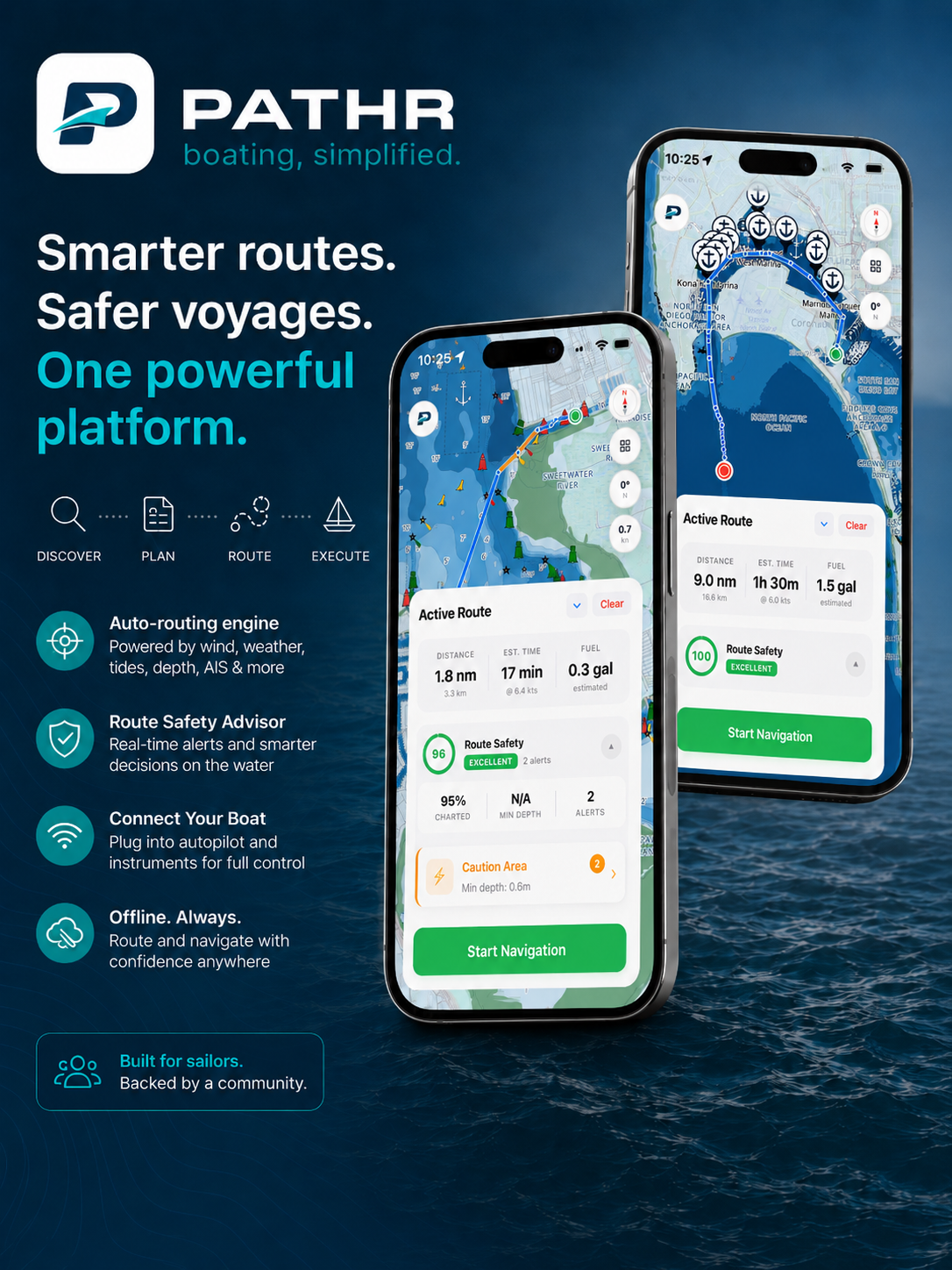
Pathr Navigation. Boating, simplified.
The product available today. A modern navigation app that takes the fragmentation, the workload, and the guesswork out of boating.
Auto-routing engine
Generates safe, captain-quality routes in seconds, informed by depth, weather, AIS traffic, hazards, and the boat's own characteristics.
Route Safety Advisor
Real-time alerts and a clear safety score on every route, so boaters know exactly what they're getting into before they leave the dock.
All-in-one map
Wind, waves, currents, radar, AIS, seabed composition, and a true marine basemap. One unified, modern experience.
Offline. Always.
Built offline-first. Download once, navigate anywhere, even when signal disappears and the trip really begins.
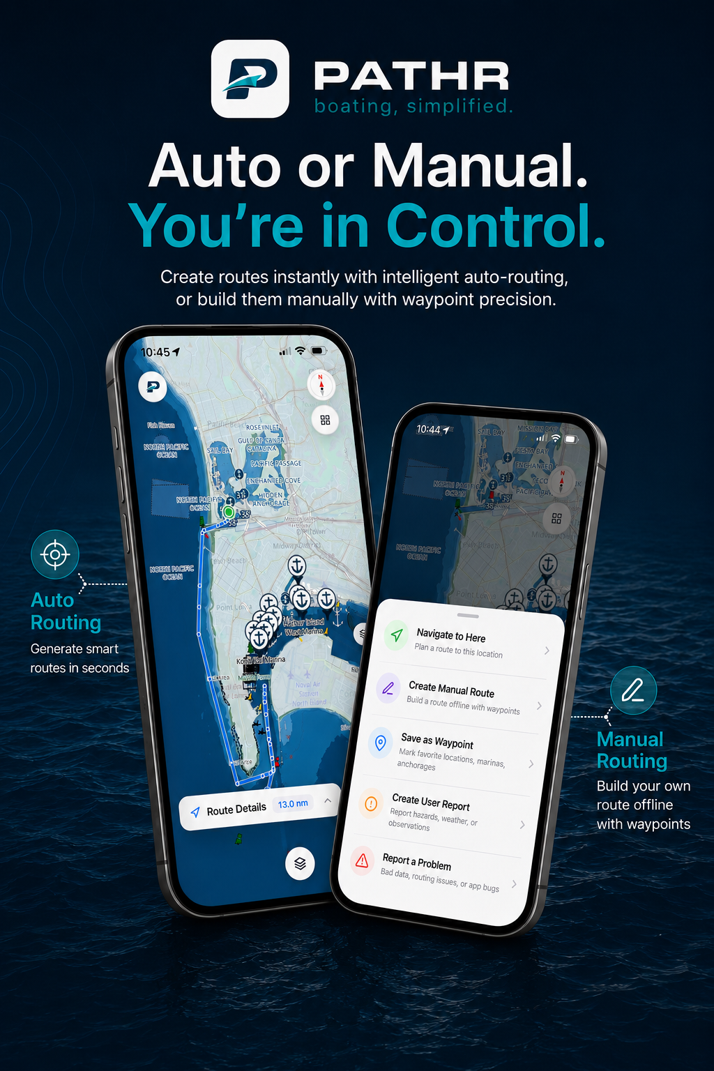
Auto or manual. The captain stays in control.
Pathr generates routes in seconds with intelligent auto-routing, or lets boaters build them manually with waypoint precision. Either way, the boater is in command. The app does the heavy lifting.
- Smart auto-routing tuned to the vessel
- Manual waypoint mode for full control
- Save waypoints, file reports, build trip history
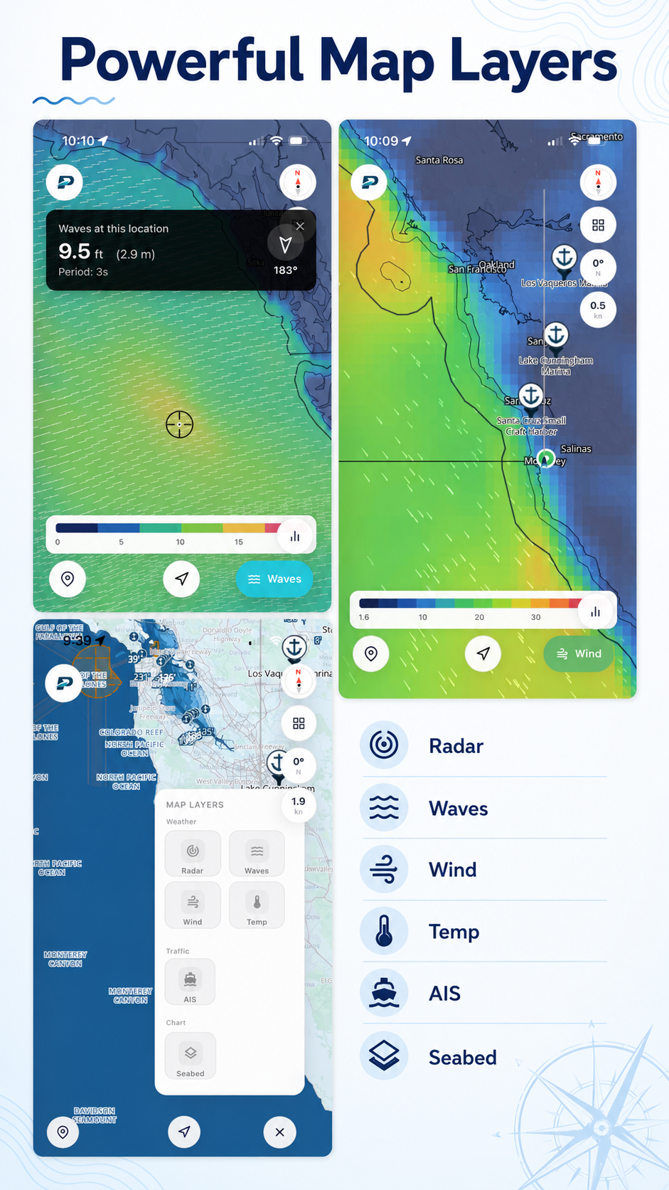
Powerful map layers in one app.
Boaters today juggle four or five apps to get a complete picture. Pathr brings radar, waves, wind, temperature, AIS, and seabed onto one map, so situational awareness lives in one place.
- Live radar, wave height, wind, temperature
- AIS vessel traffic overlay
- Seabed composition for anchoring decisions
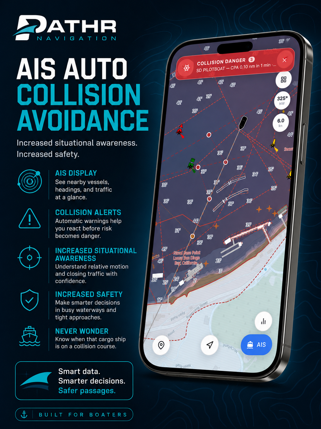
AIS auto collision avoidance.
Pathr actively monitors AIS traffic and surfaces collision warnings the moment closing traffic becomes a real risk, not after. Built for the busy waterways where most accidents actually happen.
- Automatic CPA (closest point of approach) calculations
- Proactive collision warnings with seconds to react
- Cleaner situational awareness in tight, busy approaches
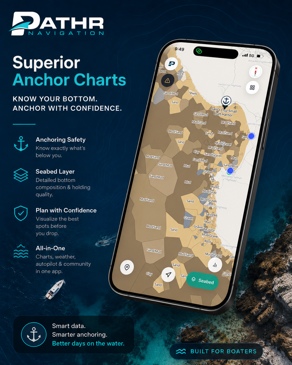
Superior anchor charts.
Most boating apps stop at depth. Pathr renders the actual seabed composition. Sand, mud, gravel, rock. So the boater knows what's below before the anchor goes down. The first truly modern anchoring layer.
- Detailed bottom composition and holding quality
- Visualize the best spots before you drop
- Built on professional nautical chart data
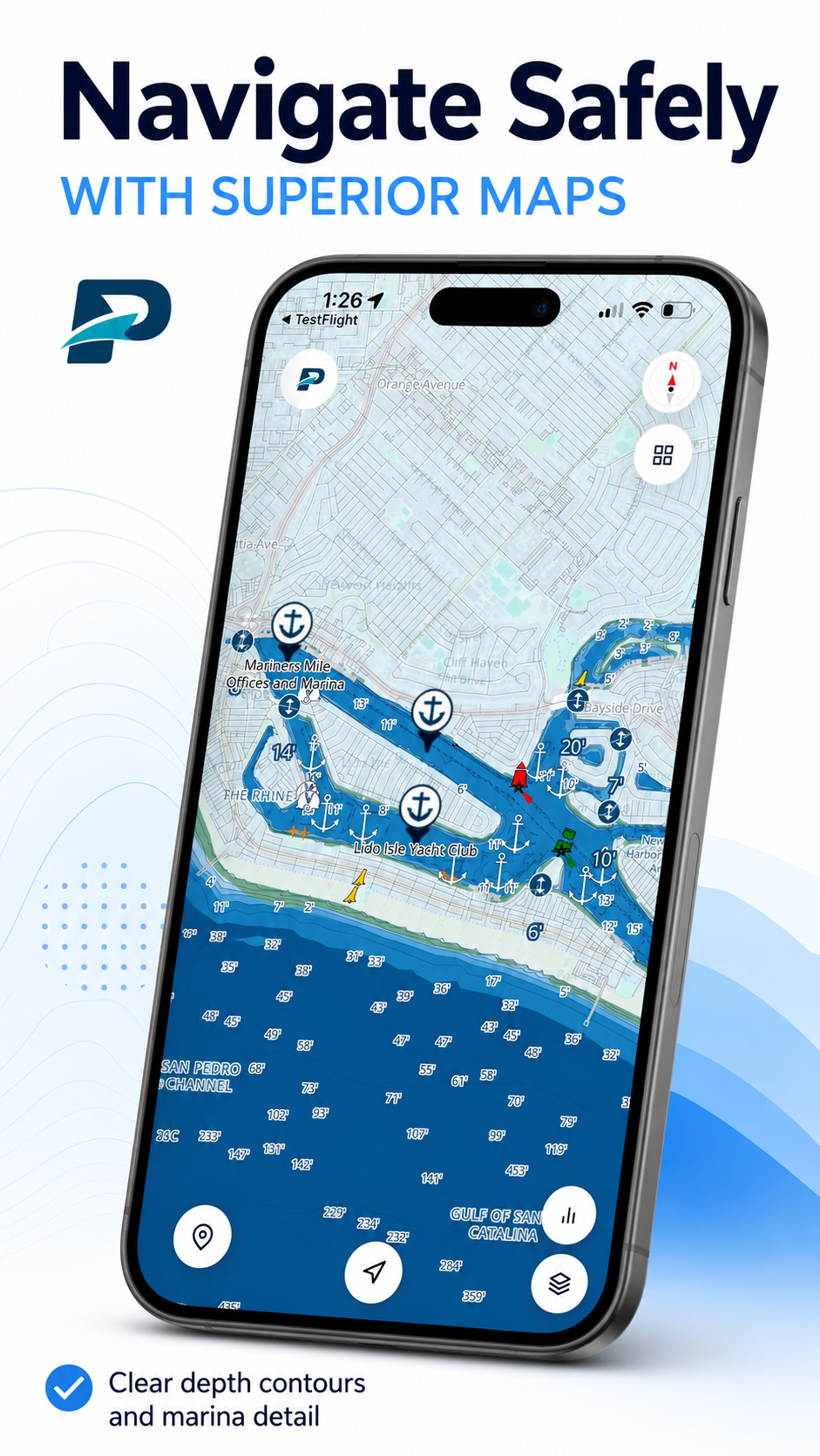
A modern marine basemap.
Clear depth contours, crisp marina detail, and a basemap that actually feels designed. Not a leftover from a 1990s chartplotter. Boaters notice the difference the first time they open the app.
- Modern, readable cartography
- Detailed marina and harbor rendering
- Depth contours engineered for real decisions
An execution-led team with real product on the water.
SmartSail isn't a deck. It's a working product, a working data stack, and a small team that moves fast.
A working iOS app, shipped. Built with React Native, deployed via EAS, iterating weekly.
NOAA S-57 charts, ENC depth tiles, OSM coastlines, seabed dissolution, AIS pipeline. Fused into one fast, queryable backend.
Visibility-graph + navmesh routing with depth-weighted costs, hazard penalties, and bridge clearance. Well beyond off-the-shelf maps.
Vessel traffic ingested, processed, and rendered in-app. Captain-grade CPA logic running on the device.
A dissolved national seabed-composition map for anchoring. A layer no major competitor ships today.
PMTiles + Martin + local caching. The app works at sea whether signal does or not.
Meet your co-captain.
The world’s most experienced captain. Trained on every trip, every boat, every set of conditions.
An AI advisor for boaters that learns from every trip, understands each vessel’s real-world performance, watches changing marine conditions, and helps captains make smarter decisions before, during, and after every journey.
Pathr is the navigation app. Pathr Co-Captain is the intelligence layer. HelmLink is the sensor bridge. Together, they become the AI co-captain for recreational boating.
Not ChatGPT for boating. A marine-trained AI system, learning from real trips, real boats, and real conditions.
Co-pilot, not autopilot. You’re still the captain.
Briefs you before you cast off.
Reads the forecast against your boat, your route, and your skill, then tells you what you'd want a sharp first mate to tell you. Departure window, what to pack, what could change, what to call off.
Watches the things you can't.
AIS traffic closing from your blind side. Wind backing 20° over the next hour. A shoaling tide near your planned turn. Sees it early, says something useful, stays quiet otherwise.
Re-plans with you, not at you.
Conditions shift. The Co-Captain proposes the next call: a different anchorage, an earlier turn-around, a re-route through the lee. Tradeoffs spelled out. You make the decision.
Looks after the boat between trips.
Tracks engine hours, fuel burn, oil intervals, batteries, sail mileage. Surfaces what's due, what's drifting, and what to plan for next month, before it becomes a problem on the water.
Specific. Grounded. Quiet when it should be.
Real Co-Captain messages from real moments. No chatbot tone. No filler. The kind of thing a sharp crewmate would actually say.
"Wind looks 10–14 from the WNW most of Saturday, building to 16–18 in the afternoon. Your Beneteau has handled this profile fine on the last three runs (avg 4h 20m). One thing I'd watch: fog is forecast offshore through about 10 AM. I'd push departure to 09:30 instead of 07:00. Want me to update the plan?"
"Tanker at 312° crossing your line in ~14 minutes, CPA 0.4 nm. Not a danger, but visibility is still 1.5 nm. Hold this heading and you'll pass safely astern. No action needed."
"Wind backed SW earlier than forecast. Your planned spot on the south side will be lee-shore by 6 PM. I'd move 0.6 nm north into the cove. Same depth, sand bottom, good holding. Adds 12 minutes to dinghy ashore."
"You're at 487 engine hours. Oil's been in since 437. No rush, but if you're at the slip this weekend, that's the cheapest hour you'll ever spend on the boat. Want me to drop a reminder on Saturday morning?"
The Co-Captain doesn't hallucinate the boat. It reads it.
Pathr already runs the routing engine, the chart stack, the AIS pipeline, the weather model, and the vessel profile. The Co-Captain reasons on top of that real data, so its advice is grounded in the same numbers a real skipper would use.
The world’s most experienced captain. Sailing with every owner.
Trained on every trip, every boat, and the conditions every other owner has ever seen.
The data the boater generates is the moat.
Public chart data is, by definition, public. Anyone can ship a viewer on top of it. What no one else collects is the live ground-truth from the boater side of the market: the boat profile, the routes actually taken, the conditions actually seen, the calls the owner actually makes.
Pathr collects it on day one. Every trip sharpens the Co-Captain for that owner. Every owner sharpens the corpus for the next. The corpus, eventually, is what underwrites the rest of the boating economy: insurance, services, valuation, charter.
Owner-side data flywheels are won by the first credible app the market adopts. Hardware can't reach the phone. Chart apps can't reach the boat. The first software the owner trusts on the water keeps everything downstream of it.
Three inflections. One window.
The customer is turning over. The AI is real. The marine data is finally queryable. None of these were true at the same time three years ago. All of them are true now.
Boating's app-native moment.
A typical weekend trip today is built across weather sites, paper notes, a chartplotter from the 1990s, and four or five disconnected phone apps. The expectation that closing that workflow loop is normal has shifted under the incumbents' feet. Buyers now expect software on their boats the way they have it everywhere else in their lives.
Vertical agents finally work.
Frontier models can now reason over a vessel profile, a live AIS feed, a forecast model, and a route at the same time, in seconds. Forty-five percent of marine startups are shipping AI in 2025, up from twenty-seven the year before. The category window is open. It closes when the first credible owner-side platform wins.
Marine inputs are finally queryable.
S-57 charts, ENC depth tiles, real-time AIS, satellite weather, modern bathymetry, public bridge databases. Every input an AI working partner needs is now public, queryable, and inexpensive to ingest. The marine data backbone wasn't possible to build for a small team five years ago. It is now.
A uniquely capable team, purpose-built to execute.
Three founders. Aviation-grade discipline, commercial-scale engineering, and award-winning product chops, all on the same boat.
- Flight test engineer on safety-critical autonomous systems
- National Test Pilot School graduate
- Sailing since childhood; competed nationally in junior sailing
- Tests Pathr on his own Catalina 38
- Founding engineer at an automation startup acquired by a $1B+ technology company
- Full-stack geospatial engineer
- IoT systems architect
- Built remote-control hardware and cloud systems at commercial scale
- Pre-Series startup experience
- Award-winning innovative product developer, concept to commercialization
- Rapid & frugal prototyping expert
One intelligence layer per vertical. We're building boating's.
We're meeting with the operators, partners, and investors building the next decade of marine software. Thirty minutes on Lucas's calendar, no deck required.